Pulitzer Center Update April 14, 2026
'Panorama': A New Quarterly Report on Gold Mining in the Amazon

The Amazon Mining Watch (AMW) platform, created through a collaboration between the Pulitzer Center, Earth Genome, and Amazon Conservation to monitor mining activities in the Amazon basin, has introduced a new addition: "Panorama," a quarterly report that identifies hotspots and the areas most recently affected.
AMW uses artificial intelligence to detect the scars left by mining on the rainforest in satellite images. It contains annual data for the 2018-2024 period and, since last year, has been processing new data every three months.
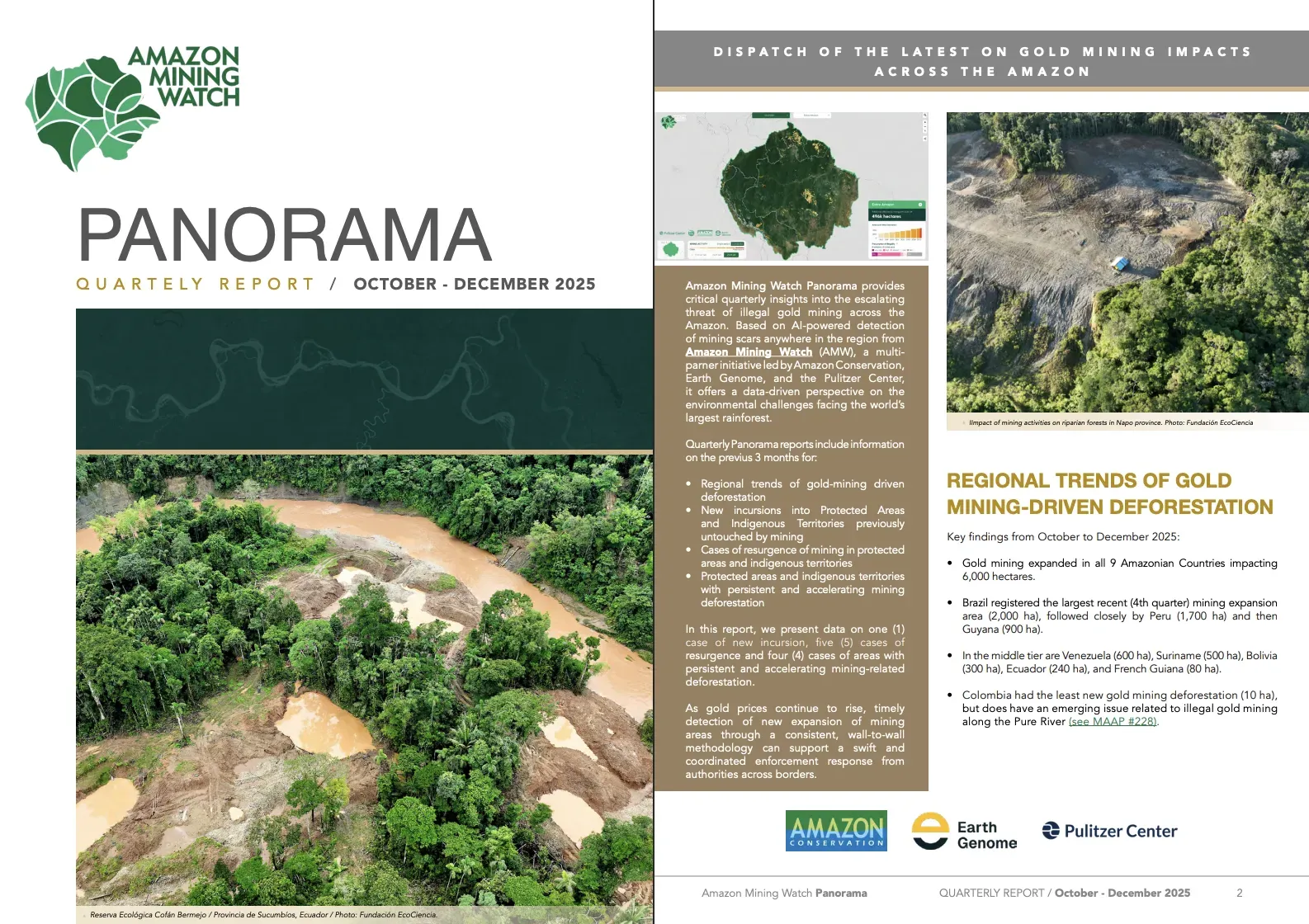
Panorama helps make sense of the latest data from AMW, revealing regional trends in mining within protected areas and Indigenous territories—whether these involve new incursions into previously unaffected areas, the resurgence of mining in zones where it appeared to have ceased, or the persistence and acceleration of mining where it was already taking place. For each of the cases analyzed, the report includes a link to AMW’s interactive map to understand the context and explore the data over time.
The first report, covering October-December 2025, is now available as a PDF on the Panorama website and shows the continued expansion of mining across the nine countries in the basin. For the aforementioned period, it estimates 6,000 hectares of new deforestation linked to gold mining—more than 17 times the size of New York’s Central Park—with the most affected countries in absolute terms being Brazil (2,000 hectares), Peru (1,700 hectares), and Guyana (900 hectares).

Some Critical Mining Hotspots in the Amazon
Among the 10 mining cases analyzed in the first issue of Panorama, the following stand out: a new mining incursion in Ecuador, a resurgence of mining activity in Guyana, and ongoing deforestation linked to mining in Peru.
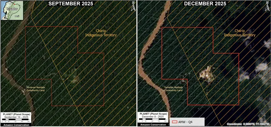
New Incursion: Charip Territory (Ecuador)
The Charip Territory, home to the Shuar Indigenous people and located in the province of Sucumbíos, was officially recognized in 2025 and recorded its first evidence of mining activity in the last quarter of that same year—at least since 2018. The identified incursion marks the start of mining activity in the area, consistent with the expansion of mining activity in Ecuador.
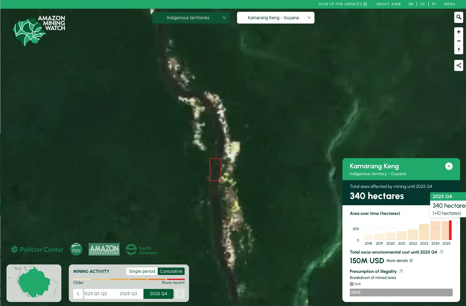
Resurgence: Kamarang Keng (Guyana)
The Kamarang Keng Indigenous Territory, established in 1991 in the Upper Mazaruni region, has seen a resurgence of mining activity following a period of no recent expansion. After signs of a decline in activity, nearly 10 hectares of new affected areas were detected in the last quarter of 2025. The territory is inhabited primarily by the Akawaio people and is legally recognized as Titled Amerindian Village Land.
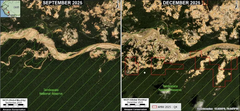
Persistence and Acceleration: Tambopata (Peru)
The Tambopata National Reserve, in Madre de Dios, continues to see sustained expansion of mining within its boundaries. During the last quarter of 2025, more than 200 hectares of new deforestation linked to this activity were identified. The protected area, created in 2000 and classified as an IUCN Category VI protected area, is one of the most biodiverse regions in the Amazon.
Amazon Mining Watch and Panorama: Tools for Investigative Journalism
These data-driven tools are key allies for investigative journalism, as they allow you to identify patterns, track changes over time, and uncover leads for potential investigations.
In addition to subscribing to Panorama’s quarterly insights, we invite you to explore AMW’s interactive map, which features annual and cumulative data over time for the entire Amazon region.
In AMW, you can view the information by country, subnational jurisdiction, protected area, or Indigenous territory. All data is available for download, so you can work with it in geospatial analysis software like QGIS. The platform also provides a “Presumption of Illegality” layer data, which identifies, for each area where mining is detected, the likelihood that the mining activity is illegal.
If you’re looking for ideas for potential reports using AMW in your country, check out this post. You can read about different projects that used these tools to track clandestine airstrips or challenge official deforestation data.
Also, we have plenty more tools for researching climate and environment-related topics on our resources page, including methodologies, toolkits, and databases.